Yukon中GeoSOT 编码的基本能力
示例数据:demo-geosot.udbx ,包含二维点、线、面、三维模型(精模和BIM);
SQL客户端:DBeaver或其他postgre客户端工具
可视化工具:DBeaver、QGIS或SuperMap iDesktopX;本文为展示三维场景效果,使用SuperMap iDesktopX。
二维线、面数据编码
对二维点、线、面数据的geometry列计算geosotgrid,并转换为geometry对象;
示例数据:building_point_demo、builing_line_demo、building_region_demo。
---1. 对二维点对象编码
---1.1 创建表存储二维网格结果:building_point_grid22
create table building_point_grid22
    (smid serial4 not null ,
    smgeometry geometry(polygon, 4490),
    asText varchar(765),
    grid GeoSOTGrid,idGeo int4) ;
---1.2 为 building_point_demo 表的smgeometry列构造22层网格,并将格网转换成geometry对象,写入
with a as (select smid,ST_GeoSOTGrid(smgeometry,22) as grids from building_point_demo  )
    insert into building_point_grid22(smgeometry,asText,grid,idGeo)
    select ST_GeomFromGeoSOTGrid(unnest(grids)),ST_AsText(unnest(grids)),unnest(grids),smid from a;

---2. 对二维线对象编码
---2.1 创建表存储二维网格结果:building_line2d_grid22
create table building_line2d_grid22
    (smid serial4 not null ,
    smgeometry geometry(polygon, 4490),
    asText varchar(765),
    grid GeoSOTGrid,idGeo int4) ;
---2.2 为 builing_line_demo 表的smgeometry列构造22层网格,并将格网转换成geometry对象,写入
with a as (select smid,ST_GeoSOTGrid(smgeometry,22) as grids from builing_line_demo  )
    insert into building_line2d_grid22(smgeometry,asText,grid,idGeo)
    select ST_GeomFromGeoSOTGrid(unnest(grids)),ST_AsText(unnest(grids)),unnest(grids),smid from a;

---3. 对二维面对象编码
---3.1 创建表存储二维网格结果:building_region2d_grid22
create table building_region2d_grid22
    (smid serial4 not null,
     smgeometry geometry(polygon, 4490),
     asText varchar(765),
     grid GeoSOTGrid,idGeo int4);
---3.2 为 building_region_demo 表的 smgeometry 列构造22层网格,并将格网转换成geometry对象,写入
with a as (select smid,ST_GeoSOTGrid(smgeometry,22) as grids from building_region_demo )
    insert into building_region2d_grid22(smgeometry,asText,grid,idGeo)
    select ST_GeomFromGeoSOTGrid(unnest(grids)),ST_AsText(unnest(grids)),unnest(grids),smid from a;
新生成的building_point_grid22、building_line2d_grid22和building_region2d_grid22表格可视化效果如下:

三维模型对象编码
精模数据编码
取三维模型对象的包围盒,计算三维编码,并转换为geometry对象;
示例数据:building_1。
---4. 对三维模型对象编码
---4.1 创建表存储三维网格:building_1_grid22
create table building_1_grid22 (smid serial4 not null , smgeometry geometry(multipolygonz, 4490),asText varchar(765),grid GeoSOTGrid,idGeo int4);
---4.2 为 building_1 表的 smgeometry 列构造22层网格,并将格网转换成geometry对象,写入
--- 注:st_boundary(geomodel)方法得到的Box3D,z方向起算点在地心,GeoSOT的z方向起算点在地表,所以需要进行平移处理
with a as (select smid,ST_GeoSOTGrid(st_translate(st_setsrid(st_boundary(smgeometry),4490), 0, 0, -6378137),22) as grids from building_1 )
    insert into building_1_grid22(smgeometry,asText,grid,idGeo)
    select ST_GeomFromText(regexp_replace(st_astext( ST_GeomFromGeoSOTGrid(unnest(grids)) ),'POLYHEDRALSURFACE','MULTIPOLYGON')),ST_AsText(unnest(grids)),unnest(grids),smid from a;
新生成的building_1_grid22表格与原始三维模型叠加后可视化效果如下:

BIM数据编码
步骤同上。示例数据:
效果图如下:

网格层级聚合
从已有的15层网格生成12层网格。 示例数据:bj_l。
-- 5. 生成粗糙层网格
-- 5.1 创建表存储15层级网格数据:building_line_grid15
create table building_line_grid15 (smid serial4 not null, smgeometry geometry(polygon, 4490),asText varchar(765),grid GeoSOTGrid,idGeo int4);
-- 5.1 为 bj_l表的smgeometry列构造15层网格,并将格网转换成geometry对象,写入
with a as (select smid,ST_GeoSOTGrid(smgeometry,15) as grids from bj_l  )
        insert into building_line_grid15(smgeometry,asText,grid,idGeo)
        select ST_GeomFromGeoSOTGrid(unnest(grids)),ST_AsText(unnest(grids)),unnest(grids),smid from a;
-- 5.2 创建表存储12层级网格数据:building_line_grid12
create table building_line_grid12 (smid serial4 not null, smgeometry geometry(polygon, 4490),asText varchar(765),grid GeoSOTGrid,idGeo int4);
-- 5.3 从步骤5.1的15层网格building_line_grid15生成12层网格
with a as (select ST_Aggregate(grid,12) grid , idGeo from building_line_grid15 )
    insert into building_line_grid12 (smgeometry,asText,grid,idGeo) (select ST_GeomFromGeoSOTGrid(grid),
    ST_AsText(grid), grid,idGeo from a );
geosot编码的第12层为不规则网格,本例中新生成的12层网格可视化效果如下:

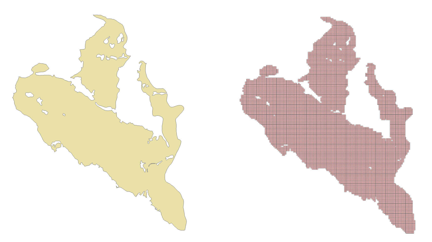
带洞的面对象编码
对带洞的面对象编码处理过程与普通geometry一致;示例数据:hole。
-- 对 hole 里的对象进行编码,并转成geometry存在tb_18表中
CREATE SEQUENCE public.tb_18_id_seq INCREMENT BY 1  MINVALUE 1 MAXVALUE 2147483647 START 1 CACHE 1 NO CYCLE;
CREATE TABLE public.tb_18 (id int4 NOT NULL DEFAULT nextval('tb_18_id_seq'::regclass) primary key, g geometry);

insert into tb_18( g)
select ST_GeomFromGeoSOTGrid(unnest(ST_GeoSOTGrid(smgeometry, 18) ) ) from hole h ;
网格化前后效果如下:
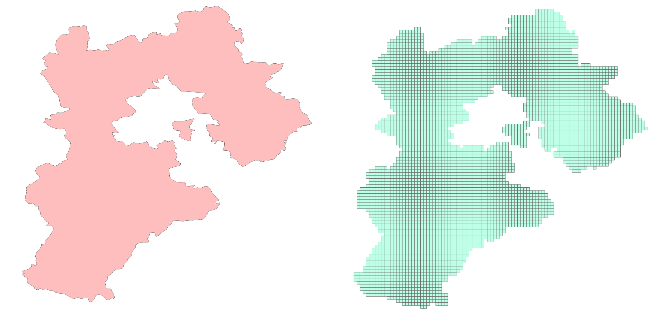
带飞地的面对象编码
对带飞地的面对象编码处理过程与普通geometry一致;示例数据:hebei。
-- 对示例数据里的对象进行编码,并转成geometry存在tb_13表中
CREATE SEQUENCE public.tb_13_id_seq INCREMENT BY 1  MINVALUE 1 MAXVALUE 2147483647 START 1 CACHE 1 NO CYCLE;
CREATE TABLE public.tb_13 (id int4 NOT NULL DEFAULT nextval('tb_13_id_seq'::regclass) primary key, g geometry);

insert into tb_13( g)
select ST_GeomFromGeoSOTGrid(unnest(ST_GeoSOTGrid(smgeometry, 13) ) ) from hebei ;
网格化前后效果如下: